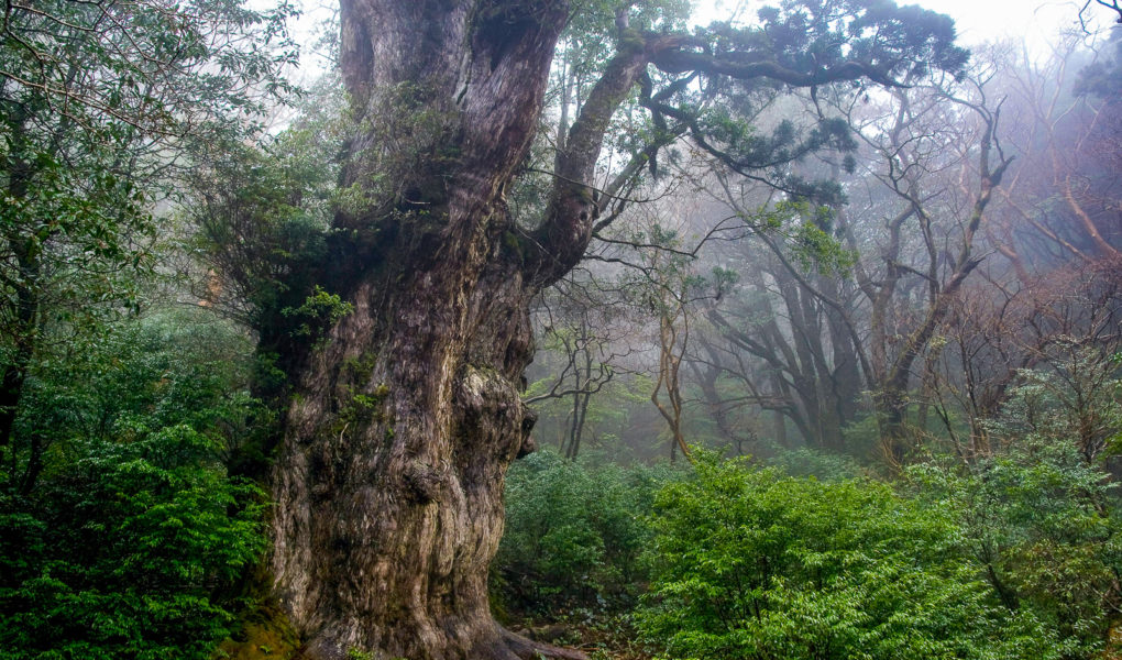
Jōmon Sugi (縄文杉), an enormous and several thousand years old cedar tree, is one of the main attractions on Yakushima. The tree, which is located deep in the mountain forest of Yakushima, is considered to be the oldest tree in Japan, and one of the oldest in the world. The actual age is unknown, but it is estimated to be between 2000 and 7000 years old.
Hotels Yakushima 15 Day Hike in the Volcanic Wonders of Kyushu
Jomon Sugi has been given it’s name because it is thought to date from the Jomon period of Japanese history (14’000–300 BCE). It was likely first discovered during the edo-period, when the area was used for logging. The tree survived and was rediscovered in the 1960’s. During the same period Yakushima National Park was established to protect the unique nature of the island. Later, a part of the forest has been designated a UNESCO World Natural Heritage site.
Despite being located far out in the forest, you shouldn’t expect to take a photo of yourself hugging the massive tree. It is forbidden to go near Jomon Sugi, which can only be observed from a platform built nearby. Even though it is a long hike out there, many hikers should be expected on the trails – especially around weekends and Japanese national holidays like “golden week”.
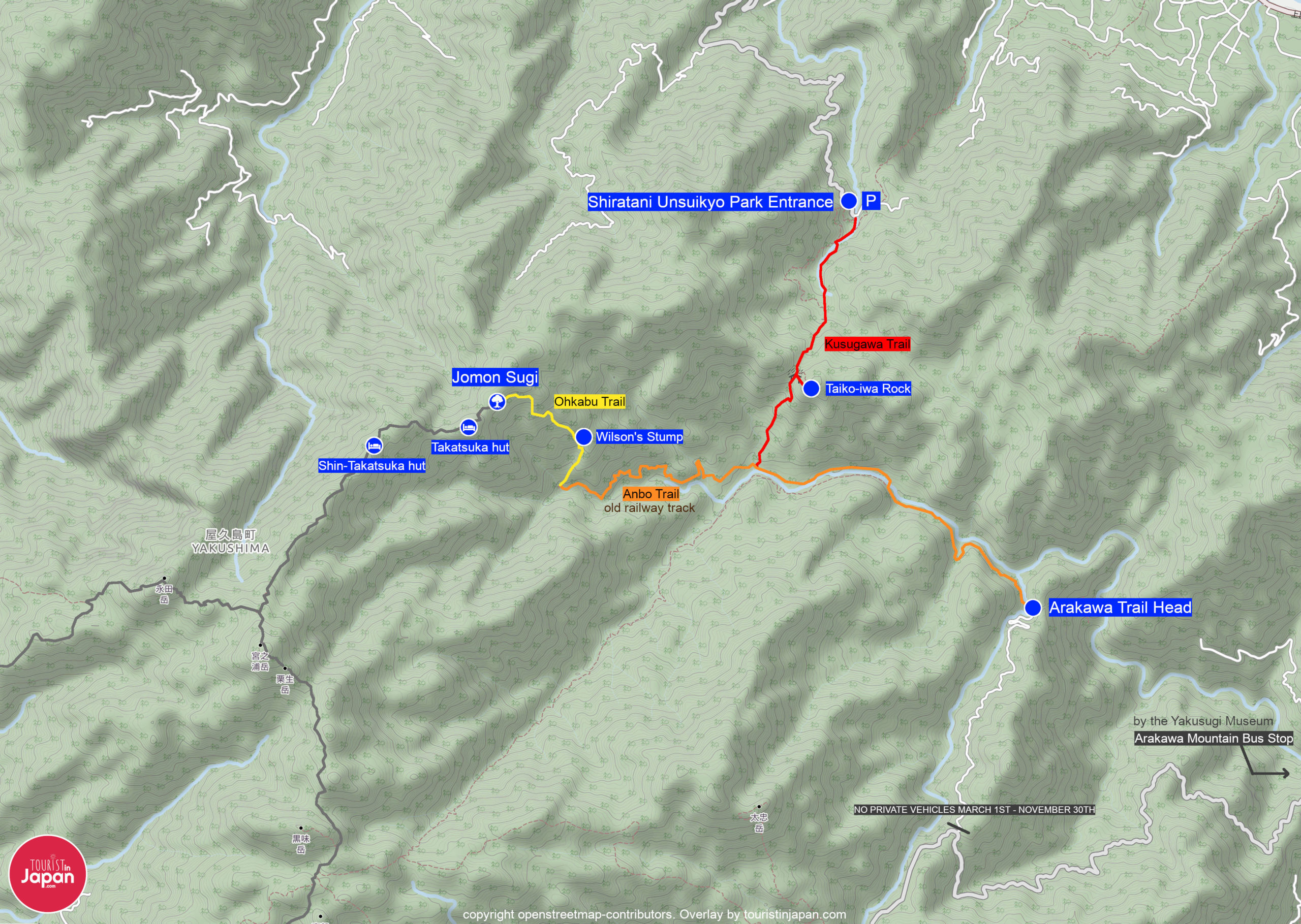
Jomon Sugi can only be reached by hiking trails. The shortest path there takes 10 hours round-trip and requires some planning ahead. There are also two huts for overnight stays within a 1km distance of the tree – the Takatsuka Hut (高塚小屋) being the nearest and the Shin-Takatsuka hut a bit further away. Yakushima’s mountains are crisscrossed by hiking trails, but there are generally two primary routes used to reach Jomon Sugi; the shortest route starting at the Arakawa Trail Head and the slightly longer path starting at Shiratani Unsuikyo Ravine park entrance. The two paths eventually merge and lead to the Ohkabu Trail which passes the tree.
Hiking trails to Jomon Sugi
From Arakawa Trail
Length: 21.2km roundtrip / 13.2mi roundtrip Time: 10-12 hours roundtrip Difficulty: medium.
Using the Arakawa Trail Entrance is the preferred route for most hikers heading to Jomon Sugi. This is because this route is both shorter and less tough. The first 8km of the trail is on the Anbo Trail which is an old railway line. The path is therefore relatively flat and not overgrown, making it possible to cover the first 8km in just 2.5 hours. The second section is the Ohkabu Trail which is a steep, mountain trail requiring proper footwear. These last 2.8km on the Ohkabu take around 3 hours (uphill).
It is absolutely necessary to leave before sunrise to be able to make a return trip. Otherwise, you must plan for camping.
From Shiratani Unsuikyo (via Kusugawa trail)
Length: 23km roundtrip / 14.3mi roundtrip Time: 12-14 hours roundtrip Difficulty: medium-hard.
Using the Kusugawa trail to approach Jomon Sugi is less common because the trail is longer and tougher. While the Arakawa Trail follows the flat old railroad for much of the distance, the Kusugawa Trail is primarily mountain trails. If using this approach, it would be wise to plan for camping or an overnight stay in one of the huts near Jomon Sugi. The Kusugawa trail has some advantages as it will be less crowded on the first section, and you won’t need to take the bus to get started. You can park your car near the Shiratani Unsuikyo Park entrance.
If time permits, then it’s worth making a short detour to see the Taikoiwa rock, which provides a magnificent view over the valleys and mountains.
Taking the Kusugawa route is risky if you plan on making a return trip on the same day. It is absolutely necessary to leave before sunrise to be able to make a return trip. It is recommended to plan spending a night at one of the huts instead.
Planning your visit
Arakawa Mountain Bus
Access to the road leading to the Arakawa Trail Head is restricted from March 1st to November 30th every year. That means no private vehicles can drive on the road. The only way to get to the trail head is to take a special Arakawa Mountain Bus. The bus departs from the Yakusugi Museum front parking lot in Anbo and costs ¥870 each way (2016).
? Show bus stop on google maps.
The Arakawa Mountain Bus departs 4-5 times in the early morning between 4:40 and 6:00 and returns 5-7 times in the afternoon between 15:00 and 18:00. Check the current schedule when you buy your tickets. There is no reservation system for tickets. Tickets should be purchased in advance at one of the following locations:
- Tourist Information Center (airport)
- Tourist Information Center (Anbo)
- Tourist Information Center (Miyanoura)
You can reach the bus stop by local busses, taxis or shuttle services provided by hotels and accomodations.
Mountain huts
There are multiple huts for overnight stays around the forest. There are two huts near the Jomon Sugi cedar. The Takatsuka Hut (高塚小屋) is very near, and the Shin-Takatsuka Hut (新高塚小屋) about 1km (1 hour) down the trail. The huts are simple and without electricity and running water. There are simple toilets available. Be prepared to share the hut with other hikers.
The huts don’t require reservation, but check current conditions with one of the three Tourist Information Centers on the island before planning to stay overnight.
Useful links
? Yakushima National Park official website
? General Hiking Map of Yakushima