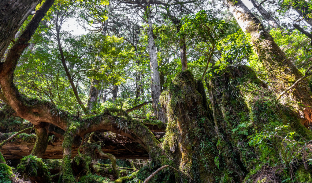
Yakusugi Land is a designated Natural Recreation Forest on Yakushima island. The park is covered in dense virgin forest with rivers, mountainsides, enormous thousand-year-old Yakusugi cedar trees and has five amazing hiking trails. There are trails suitable for every level.
Hotels Yakushima 15 Day Hike in the Volcanic Wonders of Kyushu
The ancient forest in Yakusugi Land is known for it’s serene nature. The burbles of the streams coming down the mountain, the screams of monkeys and chirps of the birds from the trees above and the thick, green moss covering everything, creates a really unique atmosphere. Walking around Yakusugi Land feels like a trip back in time, to a time when nature was mightier than man. It is no wonder that the forests of Yakushima have been the inspiration of many books, movies and video games over the years. Most famously the movie, Princess Mononoke.
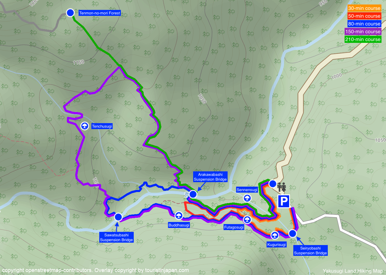
Hiking Trails of Yakusugi Land
There are 5 official hiking courses in Yakusugi Land plus the extended hike to Mount Tachudake. Of the five trails, the 30-minute and the 50-minute trails are easy courses with either wooden walkways or paved paths. The other courses are on mountain trails and require proper footwear and equipment.
30-minute course “Fureai-no-michi”
Length: 0.8km / 0.5mi Time: 30min Difficulty: easy.
The Fureainomichi path is a 30 minute long, maintained hiking path. The path is mostly either paved or equipped with wooden walkways. On this course hikers pass many stumps and large trees, and get a nice experience of the Yakushima wilderness, without going too far into the wild. The path is suitable for most visitors, also inexperienced hikers.
50-minute course
Length: 1.2km / 0.75mi Time: 50min Difficulty: easy.
The 50-minute course is maintained hiking path. The path is mostly either paved or equipped with wooden walkways. On this course hikers pass through a nice section of the forest, and will see many cedar trees, moss covered stumps, streams and rivers. The top of this circular course is at the Buddhasugi cedar tree.
80-minute course
Length: 2km / 1.25mi Time: 80min Difficulty: medium.
The 80-minute course crosses the Arakawabashi bridge where the 50-minute course doesn’t. The path continues to cross the Kokenohashi Bridge and the Tsutsujigawara riverbed, before turning back over the Sawatsubashi bridge and heading back in direction of the Buddhasugi Cedar Treee. This course is the ideal choice for less experienced hikers who want to try some real hiking, off of the paved paths. There is plenty of moss covered forest to be discovered along this charming route.
150-minute course
Length: 3km / 1.86mi Time: 150min Difficulty: medium.
The 150-minute course is a circular course like the rest, but it continues up the hill side where the 80 minute course broke off. It continues through a section of the forest which is much less frequented by visitors. Only those who are used to hiking come out here. It is a slightly tougher route, with a very simple trail. It is however incredibly beautiful and worth the extra effort. At the furthest end of the trail, by the Jamonsugi Cedar, there is a small covered hut for eating lunch or taking cover for the rain. This is where the trail goes back down the mountain, or one can continue towards the Tenmon Forest and even Tachudake Peak.
210-minute course “Tenmon-no-mori”
Length: 4.4km / 2.73mi Time: 210min Difficulty: medium.
The 210-minute course, known as the “Tenmon-no-mori course” is an extension of the 150-minute course. Where the 150-minute course turns around and goes back down the mountain, the 210-minute course continues up the mountain side. The trail ends in the Tenon-no-mori forest which is one of the 5 designated forests for academic research and information gathering on Yakushima. The Tenon-no-mori forest is not marked as such, but starts about 700m in. It is a slightly more “wild” trail the the others, and was only established in 2018.
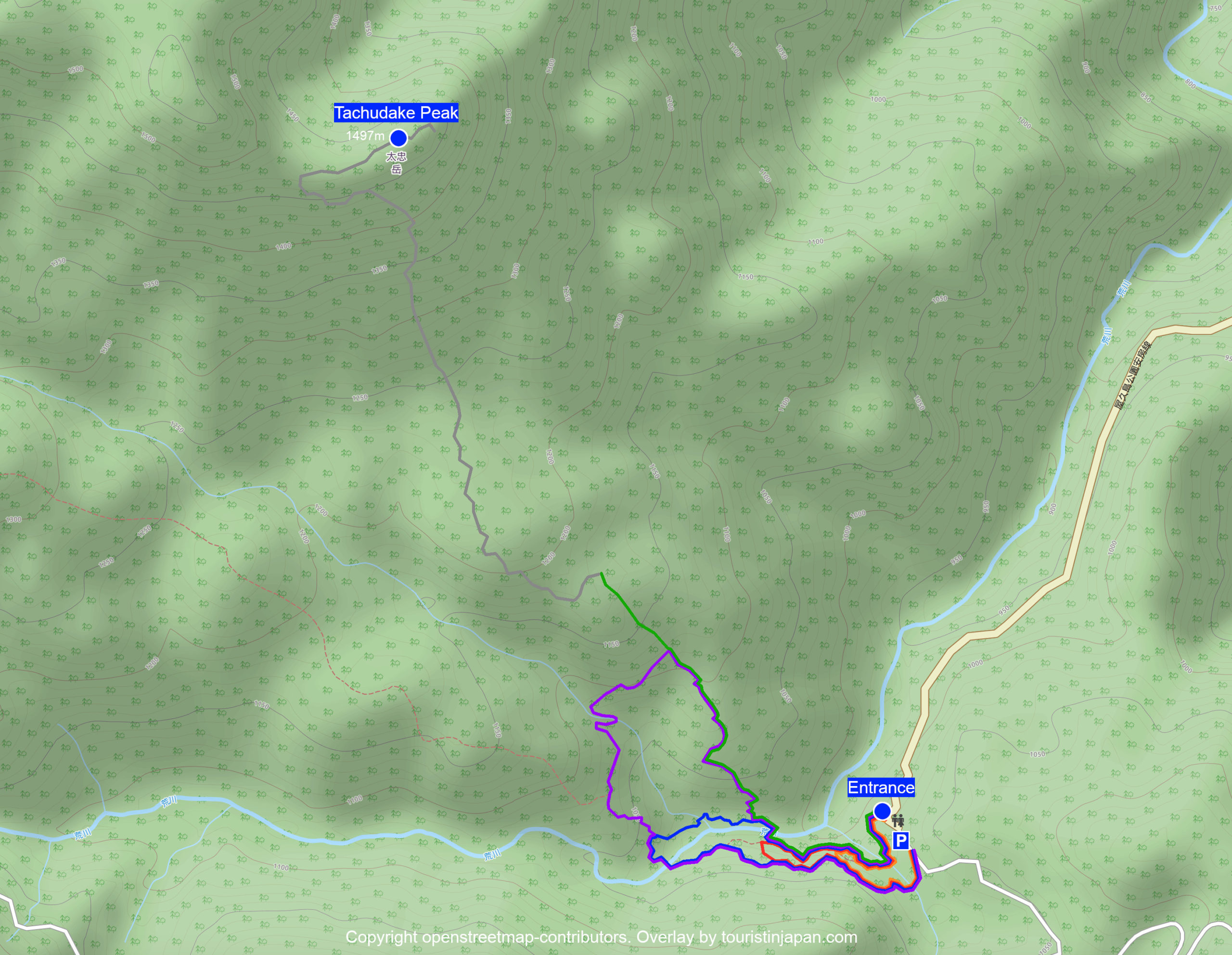
Kohanayama Path to Tachudake Peak
Length: 8km / 5mi Time: 7-8 hours Difficulty: medium-hard.
The Kohanayama course is an all-day hike, and an extension of the 150-minute and 210-minute hikes. This course is not suitable for beginners. The ultimate goal of the path is the peak of mount Tachu, Tachudake. The top of the mountain is known for it’s characteristic, standing rock which juts out of the ground, seemingly pointing towards the sky. The rock is enormous (40 meters tall), yet it seems almost man made with its flat edge and monumental look. The Tenchuseki Rock can be seen from other mountains across the island, and is a true icon.
Planning your visit
| Hours | 8:30 – 16:30 office hours Access to the park is not restricted outside office hours |
| Entrance Fee | Adults: ¥500 donation Discount coupon for Shiratani Unsuikyo Ravine is given when paying the entrance fee. |
| Website | Official website japanese |
| Hotels | Sankara Hotel & Spa ☆☆☆☆ Yakushima Green Hotel ☆☆☆ Yakusugi House ☆☆ |
Weather and Equipment
Yakushima is known for being a very rainy island at times. Therefore it is advisable to bring proper rain gear with you when you go hiking in the forest. Proper footwear is also very important as many paths are unmaintained and can get very slippery in the rain.
Getting there
By car: Yakusugi Land can be accessed by car via route 592 from Anbo town. The drive from Anbo takes around 30 minutes. There is plenty of parking available at the park entrance.
By bus: There are two bus companies operating in Yakushima; Matsubanda Kotsu and Yakushima Kotsu. Yakushima Kotsu operates a bus which stops at Yakusugi Land (stop id 71). The bus departs from Anbo Port and Anbo town 2 times daily (as of 2020).
There are 1, 2, 3 and 4-day passes available for purchase for the Yakushima Kotsu bus (can’t be used with other companies).
The time tables are generally posted at the bus stops, but the most recent time tables can be found in the download section of Yakushima Tourism Associations website.
🔗 Yakushima Tourism Association
🔗 Yakushima Tourism Association (downloads)
🔗 Yakushima Kotsu Bus Time Table 2020 (english)
🔗 Yakushima Kotsu Bus Route Map
🔗 Matsubanda Kotsu Bus Time Table 2019-2020 (english)